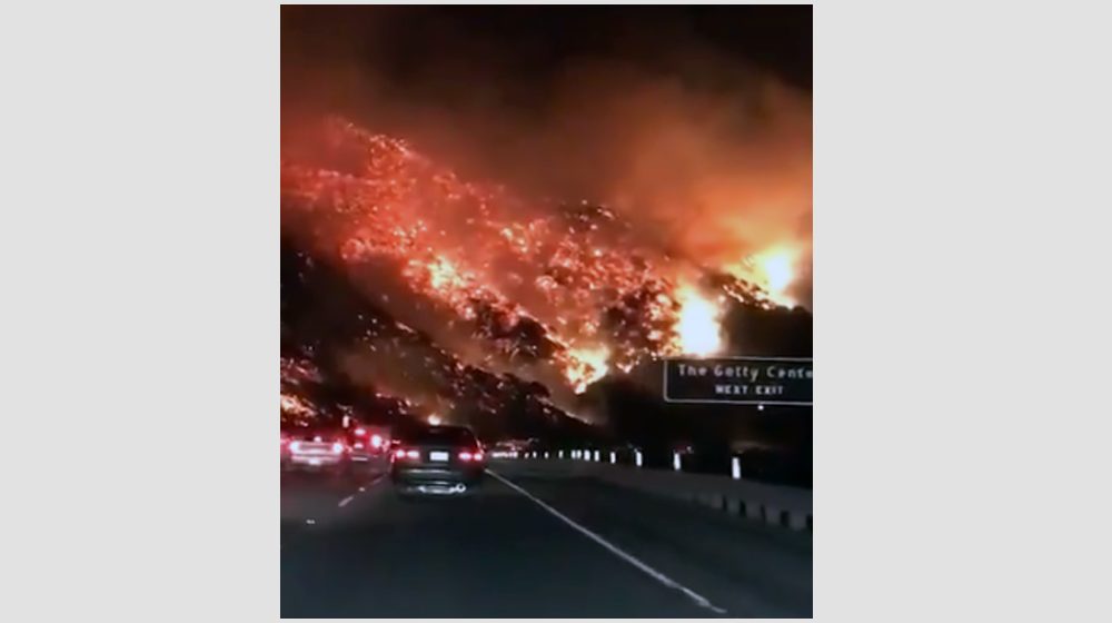
Waze, Google Maps and some other popular navigation apps sent some drivers in California into the path of the wildfires spreading through the area this week.
Nav Apps Send Drivers into Wildfires
Since these apps are automatically set to help drivers avoid areas with heavy traffic or construction, the evacuated areas were a natural draw. The apps have since made adjustments to some routes in the area. But as it’s still an evolving situation, it might not be great practice for drivers to rely solely on navigational apps when near the fires or other disaster zones.
The LAPD issued a statement discouraging drivers from relying only on navigational apps during this time, but they don’t believe there’s a systemic issue at fault.
“The Los Angeles Police Department asked drivers to avoid navigation apps, which are steering users onto more open routes — in this case, streets in the neighborhoods that are on fire.” My latest: https://t.co/knWlPoTAfl
— Laura J. Nelson ? (@laura_nelson) December 7, 2017
We’re working with the @LADOTofficial and our #WazeCommunity to keep the Waze Map updated with road closures (currently at 110) & open shelters (16) to help Southern Californians navigate safely around the #wildfires. Please help us spread the word. https://t.co/QN4T0TFD9R
— waze (@waze) December 7, 2017
Driver: “Weird. Waze says the best route away from the fire is actually towards the fire.”
Little voice in driver’s head: “BECAUSE THERE’S NO TRAFFIC THERE???”
Waze sent commuters toward California wildfires, drivers say https://t.co/phUNwcSBNB via @usatoday
— (((Merredith))) (@Merredith) December 8, 2017
For businesses that have team members traveling or transporting goods around the California wildfires, it’s important that you have alternative mapping plans in place. Apps like Waze and Google Maps can be especially helpful for business drivers looking for the fastest routes in normal circumstances. But it’s difficult for those apps to keep up with quickly evolving situations like wildfires or other natural disasters. And since this particular situation can lead to serious safety risks for drivers, it’s especially important to have alternatives in place.
Specifically, you can map out routes before leaving that you know are safe. Make sure you monitor the news and use other online tools that are updated to reflect the dangerous zones, like Google’s Crisis Map. And always keep communication open between drivers and people in your office so you can provide assistance and backup routes if necessary.
Image: @Breaking911/Twitter