Multilayer maps communicate powerfully in ways that statistics and data alone cannot. Seeing where a thing is happening brings the context of our physical reality into the picture. So what can a multilayer map do to guide public health policy? I think it’s by identifying the location of populations at risk and the pathways of transmission. These insights have already guided policy decisions to close schools and buildings, remain six feet apart, wash your hands, or stay home/stay safe/save lives. Spotting the patterns of infection by applying machine learning to 100 layers of mapping data could lead to more insights that will help health policy experts:
- Identify hotspots.
- Identify new pathways that could be blocked or mitigated.
- Decide which groups and how far to lock down for social distancing.
- Know when the risk of transmission has dropped to a low enough level to allow work, school, etc.
How can we build a multilayer map to do this?
A little history could help here. (Skip to the bottom if you want a list of innovative multi-layer maps tracking COVID-19 and its effects.)
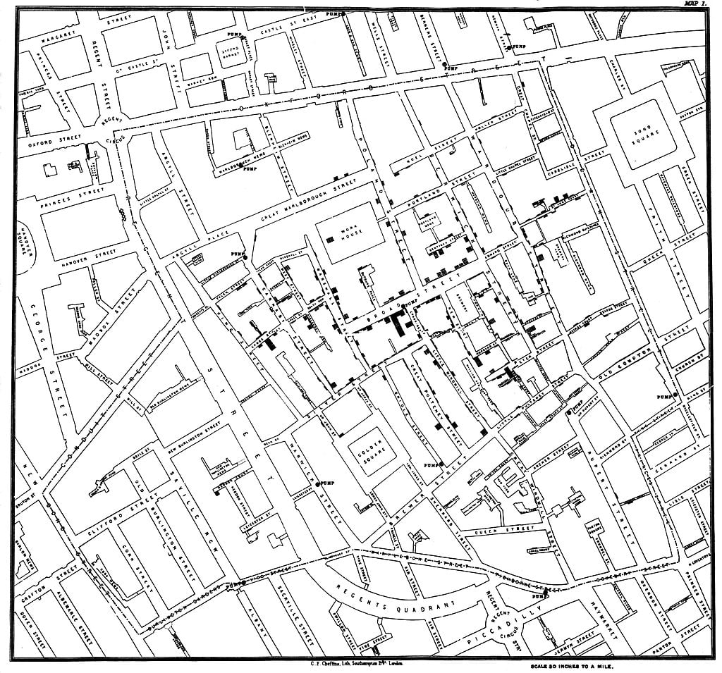
A multilayer map revealed the source of cholera: it’s the water, not the miasma
When cholera swept London in the years 1846-1860, it was only when physician John Snow (yep, that’s his name) recorded the deaths in 1854 on Broad Street and showed that people using the neighborhood water pump were dying from cholera that he convinced the authorities that the bacteria travels in water, not via smelly “miasma” in the air. That intelligence ultimately led to a new public policy — boil the water before drinking it! — and led to massive investments in water and sewage infrastructure. None of that was clear before looking at that multilayer map as author Steven Johnson explains.
https://commons.wikimedia.org/wiki/File:Snow-cholera-map-1.jpg
What about the novel coronavirus?
So what can multilayer maps tell us about the pathways driving the spread of the novel coronavirus?
We already know about airborne transmission and the role that airplanes, trains, and public gatherings played. We suspect that mass gatherings like Mardi Gras in New Orleans and perhaps Kobe Bryant’s memorial concert in LA could create hotspots of infection. We’re warned of infection on doorknobs and elevator buttons. We now even know that the loss of smell and taste correlates with likelihood of infection.
But what else is out there? How important are each of these transmission pathways? How can we give everybody guidance on how to know whether they are at risk or in fact a carrier? This is where multilayer maps come in.
By capturing (with all the proper privacy protections in place) the behavior of everybody, including their location, physical path through the day, and mode of transportation and connection (were there are many people in the car, for example), and correlating that with known information about infection rates (yet another reason that widespread testing is important), or even searches on “coronavirus smell loss” gives data scientists and epidemiologists a powerful tool to investigate hotspots and transmission pathways.
This requires a multilayer map, one with the base mapping data; contextual data like roads and places; dynamic data like your “blue dot” and wind and temperature and crowds and travel routes; and intelligent layers like safest route algorithms.
Apple, Google, and Facebook have the most and best information about people’s location, Apple and Google because they own the mobile operating systems, and Facebook because it’s, well, Facebook. And Microsoft because it’s, well, Microsoft. What can and should they be doing to help public policy officials in every country? They will need to protect identities with as much anonymization as possible. Even so, they should probably ask people to opt in to share their location data (though we doubt they have the systems in place to do that right now).
Even once the curve flattens, we will need this ability to manage infection hotspots until therapeutics and a vaccine is ready, and it will prepare us for the next pandemic.
How can this happen? If you speak loudly enough about it to your platform vendors, that could help put pressure on them to do the right thing while protecting you.
Multilayer Mapping Projects Focused on COVID-19 and Its Impact